Showing posts with label electronic compass. Show all posts

Tuesday, April 29, 2025

HDD technology breakthrough! North seeker helps with orientation in trenchless construction


As the core technology of trenchless pipeline laying, HDD technology places extremely high demands on the direction control of the drill bit. The precise control of the drilling trajectory depends on high-performance directional measurement equipment. With its unique technical advantages, the ER-MNS-09 north seeker has become a key equipment for improving construction efficiency and accuracy in HDD operations.

Core challenges and directional requirements of HDD construction

HDD construction requires the completion of pilot hole drilling, hole expansion, and pipeline pullback processes underground. Directional equipment needs to meet the requirements of narrow space adaptation, high-precision orientation, resistance to complex environmental interference and impact vibration, and adaptation to extreme working conditions.

ER-MNS-09’s technical advantages and HDD compatibility

**High-precision measurement to ensure trajectory control**

The azimuth accuracy can reach 0.25°, and the attitude accuracy is ≤0.2°. With a data update rate of 100Hz, it supports stable operation in the inclination range of -85~85°. The operator can adjust the drill bit trajectory in time based on the measurement data to meet the strict restrictions on trajectory deviation in HDD construction;

**Ultimately compact design, embedded in the core space of the probe tube**

The HDD guided probe pipe needs to be embedded in the front end of the drill pipe, and the size and weight of the equipment are limited. The ER-MNS-09 north seeker has a diameter of only 30mm, a length of 120mm, and a weight of ≤150g. It can be seamlessly integrated into the probe pipe or guide head at the front of the drilling equipment, and is suitable for mainstream drilling equipment.

**Autonomous north finding and anti-magnetic interference**

Adopting a high-precision MEMS gyroscope that can self-find north, the initial alignment is completed in 5 minutes, completely free from dependence on the geomagnetic field, and can stably output the true north azimuth, pitch angle and roll angle information in strong interference environments such as underground mines, metal pipelines or strong electromagnetic environments.

All-solid-state design: no mechanical rotating parts, excellent anti-impact and vibration ability, meeting the reliability requirements under severe vibration conditions during drilling.

**Wide temperature adaptability to cope with extreme working conditions**

Full temperature calibration compensation: The normal temperature version supports an operating temperature of 5~+55°C, and the high temperature version supports 5~125°C. It can withstand strong vibration and shock environments to ensure long-term reliability in deep wells, mud environments or high shock conditions.

more details: https://www.ericcointernational.com/north-finders/mems-triaxial-north-seeker-for-mining.html?utm_source=blogger&utm_medium=blog&utm_campaign=mining_north_seeker

Thursday, April 24, 2025

Precise application of high-performance dynamic FOG north seeker in mining and oil exploration


The orientation accuracy of drilling equipment directly affects the efficiency and safety of logging drilling, tunnel excavation, and ore body positioning. During underground drilling operations, the vibration and attitude changes of the drilling rig are frequent, and traditional mechanical gyroscopes or magnetic compasses are difficult to work stably.

For more details: https://www.ericcointernational.com/north-finders/high-performance-dynamic-fog-north-seeker.html?utm_source=blogger&utm_medium=content&utm_campaign=north_seeker_blogger&utm_content=product_review_article

ER-FNS-01D high-performance dynamic FOG north seeker can achieve real-time accurate north seeking and attitude following in a vibrating environment. The north seeking accuracy can reach 0.5°, and the attitude measurement accuracy can reach 0.03° (1σ). Dynamic north-seeking technology can provide the true north direction of the carrier in real time. The working latitude of 65°N-65°S covers major mining areas and oil and gas fields around the world, ensuring that the drilling rig can still accurately control the drilling direction even when tilted or vibrating.

The compact size of 100×100×75mm and the lightweight design of 1kg make it easy to integrate into drilling equipment. Its core technical advantages are precisely targeted at complex working conditions:

Fast and precise dual modes: Supports 30-second fast alignment (azimuth accuracy 1°) and 90-second precise alignment (azimuth accuracy 0.5°), significantly shortening the equipment startup time. It can quickly establish the north reference after the drilling rig is in place. At the same time, its 20-minute accuracy retention capability allows the drilling rig to quickly resume operations after a short stop, reducing the time loss caused by repeated alignment.

Full environment adaptability: 5℃-55℃ full temperature range compensation technology adapts to the temperature difference between the deep mine and the field; there is humidity, dust and potential electromagnetic and metal interference in the mine, and the ER-FNS-01D is not affected by the magnetic field, which completely avoids the influence of the electromagnetic environment on the measurement results.

Strong vibration adaptability: The built-in shock absorber design can withstand 20Hz-2000Hz, 6.06g vibration environment, solving the problem of accuracy drift caused by vibration in dynamic operations of traditional north-seeking equipment.

Thursday, January 23, 2025

🔎 𝗠𝗮𝘅𝗶𝗺𝗶𝘇𝗶𝗻𝗴 𝗛𝗼𝗿𝗶𝘇𝗼𝗻𝘁𝗮𝗹 𝗗𝗶𝗿𝗲𝗰𝘁𝗶𝗼𝗻𝗮𝗹 𝗗𝗿𝗶𝗹𝗹𝗶𝗻𝗴 𝗦𝘂𝗰𝗰𝗲𝘀𝘀:𝗧𝗵𝗲 𝗙𝘂𝘁𝘂𝗿𝗲 𝗼𝗳 𝗨𝗻𝗱𝗲𝗿𝗴𝗿𝗼𝘂𝗻𝗱 𝗗𝗿𝗶𝗹𝗹𝗶𝗻𝗴 𝗔𝗰𝗰𝘂𝗿𝗮𝗰𝘆 𝗜𝘀 𝗛𝗲𝗿


❎ Horizontal directional drilling technology completes the task of laying underground pipelines without destroying the surface environment. However, the practical application of this technology faces the challenge of accurately determining the drilling direction in complex underground environments.
✅ As an instrument that can accurately measure the true north direction, the north finder provides an effective solution to the problem of determining the direction of horizontal directional drilling.
👉 Take the ER-MNS-09 north finder as an example. It is a cylindrical north finder developed specifically for drilling. It is not restricted by the external environment and is not interfered by the magnetic field. It can provide azimuth and attitude information by itself.
👉 It can be used in machines such as HDD tools, gyro tools and underground tunneling machines to reduce measurement errors.
🔷 Unique shape, flexible installation 🔷
👉 The cylindrical shape is 120mm in length and only 30mm in diameter, and the weight is ≤150g. It can be installed in the probe behind the drill bit.
🔷 High-accuracy North Seeking 🔷
👉 The north-seeking accuracy can reach 0.25°secψ(1σ), which can achieve high-precision directional measurement and meet the strict accuracy requirements of horizontal directional drilling.
👉 Measure azimuth and attitude angle (pitch, roll) independently. The measurement error of azimuth is controlled within a very small range, providing reliable guarantee for drilling construction.
🔷 Self-alignment and attitude tracking function 🔷
👉 After startup, it can automatically initialize alignment and then automatically determine the true north direction. The north search time only takes 5 minutes. It can also track and provide attitude information.
🔷 Adapt to harsh environment, stable and reliable 🔷
👉 It can resist strong impact and vibration. The working temperature range of the normal temperature version is 5°C~+55°C. The working temperature range of the high temperature version is 5°C~+125°C.
❤️ 𝙄𝙛 𝙮𝙤𝙪 𝙖𝙧𝙚 𝙞𝙣𝙩𝙚𝙧𝙚𝙨𝙩𝙚𝙙 𝙞𝙣 𝙩𝙝𝙚 𝙄𝙈𝙐 𝙙𝙖𝙩𝙖𝙨𝙝𝙚𝙚𝙩 : https://lnkd.in/eDyWMuWz
𝙥𝙡𝙚𝙖𝙨𝙚 send email to : ericco188@ericcointernational.com

Tuesday, December 10, 2024

Is there an error in drilling trajectory control? The north finder installed near the drill bit makes drilling more accurate!


 Directional well technology is one of the most advanced drilling technologies today. Based on actual cases, the main problem of directional wells is the control accuracy of the trajectory. The directional tool will deviate from the trajectory and the measurement error is large. There is also a trajectory prediction error caused by the MWD being a certain distance away from the drill bit.

We have developed a new cylindrical north seeker ER-MNS-09 to address these problems, which can be installed close to the drill bit and directly in the drilling rig’s exploration pipe. It can be used in gyro tools or HDD tools.

**Near-drill-bit installation**

This is an aluminum alloy cylindrical MEMS north finder, 120mm long and only 30mm in diameter, light in weight and with good thermal conductivity. It can be directly installed near the drill bit or in the drill rig probe, and can independently measure the azimuth and attitude angles, more accurately control the well trajectory and reduce errors.

**High-precision north-seeking orientation**

The north-seeking accuracy of this north finder can reach 0.5°secψ(1σ), which can provide more accurate azimuth information. This is crucial for drilling operations that require precise orientation. At the same time, it is not affected by magnetic interference and can also be used in magnetic mining areas.

**Self-alignment and attitude tracking function**

After startup, it can automatically initialize alignment and then automatically determine the true north direction. No manual alignment is required, and the north-seeking time only takes 5 minutes. It can also track and provide attitude information to ensure that the drilling trajectory meets the design requirements.

**Adapt to harsh environment**

During the drilling process, there will be strong impact and vibration. It can resist high impact vibration and ensure stable operation. There is also a high temperature version with an operating temperature range of 5°C~+125°C. The low power consumption design of only 2W ensures stable output under continuous working conditions.

This north finder is designed to be more suitable for applications such as oil mining and drilling, especially in situations where precise control is required.

If you are interested in this and would like to know its data sheet.

For more information, please indicate in the “Ask for a Quote” box at the bottom of the page that you learned about this North Finder from Blogger.
https://www.ericcointernational.com/north-finders/mems-triaxial-north-seeker-for-mining.html

You can also take a screenshot and send it directly to this email address: ericco188@ericcointernational.com

Friday, November 1, 2024

An IMU designed specifically for drones, with multiple sensors integrated


Sensors are the core components of drone flight control systems, which can help drones achieve multiple functions such as attitude control, navigation, flight control, etc.

A basic drone needs to have characteristics such as stability, accuracy, low power consumption, and environmental perception. We currently have an IMU ER-MIMU-16 that perfectly meets these requirements.

**Multiple high-performance sensor integration**

Most IMUs only have built-in gyroscopes and accelerometers. Our IMU integrates sensors such as gyroscopes, accelerometers, magnetometers, and barometers (altimeters), which are very suitable for drones.

Gyroscope: dynamic measurement range: ±450º/s, bias instability :0.3º/h;

Accelerometer: dynamic measurement range: ±30g, bias instability: 10ug;

Gyroscopes and accelerometers provide the angular velocity and acceleration of the drone. These data can be calculated to obtain information such as the drone's attitude, speed, and displacement.

Magnetometer: dynamic measurement range ±2.5Gauss, can measure the strength and direction of the magnetic field, and provide the magnetic north direction.

Barometer: pressure range 450~1100mbar, by measuring atmospheric pressure, the data provided can assist the drone in navigation, rise to the required height, and accurately estimate the ascent and descent speeds.

**Lightweight design, easy to install**

This IMU has a volume of 47×44×14mm, a thickness of only 14mm, and a weight of 50g. It can be easily installed in various drones.

**SPI communication interface**

This type of communication method has a high data transmission rate and can perform high-speed data communication. It can also send and receive data at the same time, doubling the efficiency.

If you are interested in this and would like to know its data and price

For more information, please indicate in the “Ask for a Quote” box at the bottom of the page that you learned about this North Finder from Blogger.https://www.ericcointernational.com/inertial-measurement-units/low-cost-inertial-measurement-unit.html

You can also take a screenshot and click on the email to ask for detailed information immediately: ericco188@ericcointernational.com 

Wednesday, October 30, 2024

The integrated navigation: escorting safe flight of drones

 The integrated navigation: escorting safe flight of drones


GNSS systems (such as GPS, GLONASS, BDS, etc.) provide positioning services with global coverage, but the signals may be blocked or interfered with. They are usually combined with inertial navigation systems to form the integrated navigation system, which can be used in various unmanned systems.

At present, integrated navigation has been widely used in UAVs. It can perform positioning and orientation, and provide attitude, heading and altitude information to the flight control system of the UAV.

The flight control system combines other sensor information to achieve automatic flight, and can also use the combined attitude information to achieve fuselage attitude stability.

We have an integrated navigation system ER-GNSS/MINS-05, which is the most cost-effective one. It has high reliability and is reasonably priced.

1. The product has highly reliable and low-cost MEMS gyroscopes (bias instability <2°/h) and accelerometers (bias instability <24ug).

2. The integrated navigation information provided has roll and pitch accuracy up to 0.1°, post-processing 0.03°, heading 0.1°, post-processing 0.05°, and speed accuracy up to 0.03m/s.

3. Built-in full-band full-system dual-antenna positioning and orientation GNSS module. Single antenna can perform high-precision positioning and speed measurement. Dual antennas can be quickly oriented and can provide high-precision heading and attitude information, which is crucial for applications such as drones and ship navigation.

4. It also has a variety of data interfaces, easy installation, and supports RS422/RS232 and CAN. It is sufficient to meet applications in most cases.

5. It can be widely used in land, aviation, navigation and other fields, including but not limited to autonomous driving, precision agriculture, drones, unmanned surface vehicles, etc.

For more information, please indicate in the “Ask for a Quote” box at the bottom of the page that you learned about this North Finder from Blogger.:  https://www.ericcointernational.com/inertial-navigation-system/mems-inertial-navigation-system/cost-efficient-gnss-aided-mems-ins.html

Email: ericco188@ericcointernational.com 


Tuesday, March 5, 2024

Soft Magnetic Error Compensation Method of Electronic Compass


1. Analysis of soft magnetic error of electronic compass

There is another ferromagnetic substance in the working environment of the electronic compass sensor, which, unlike hard ferromagnetic materials, is easily magnetized in a weak magnetic field. When the external magnetic field changes, its induced magnetism will also undergo a related change. The size and direction of the induced magnetic field will also change with the attitude and position of the carrier.
Because of its special properties, this material is called soft iron material. This soft iron material magnetizes itself due to the size of the external magnetic field it receives to produce a magnetic field that resists changes in magnetic flux, which can vary over a wide range. If the magnetic field in the space where the electronic compass sensor is located is known, the magnetic field actually measured by the electronic compass sensor is equal to the superposition of the geomagnetic field and the magnetic field generated by the soft iron interference. The soft iron error is equivalent to a time-varying error superimposed on the output of the electronic compass sensor. Because of the different properties of soft magnetic interference error and hard magnetic interference error, the least square method is no longer applicable when compensating soft magnetic interference error. Soft magnetic interference will lead to the deviation of the measurement Angle of the electronic compass. In an ideal environment, the Angle rotated by the measurement of the electronic compass is controllable, but the existence of soft magnetic interference error will lead to the deviation and uncontrollable Angle of the measurement process of the electronic compass. In the application of navigation system, a small Angle difference will lead to a large route error. The modern electronic compass has strong anti-interference and can suppress most of the Angle deviation, but the compensation of soft magnetic error is still worth studying and discussing.

2. Soft magnetic interference error compensation method
In the actual use of electronic compass, the noise errors caused by soft magnetic interference are mostly random noise errors. At present, there are many algorithms that can be used to compensate random noise and most of them are relatively mature, but considering the characteristics of electronic compass requiring real-time and rapid processing of large amounts of data. Three very mature random noise compensation algorithms, namely Kalman filter, improved Sage adaptive Kalman filter and particle filter, are selected as soft magnetic interference compensation algorithms. These three algorithms are easy to implement and can handle dense data.

2.1 Kalman filter
Kalman filtering algorithm can estimate the linear system with Gaussian white noise, which is the most widely used filtering method at present, and has been well applied in the fields of communication, navigation, guidance and control. The basic idea is that the minimum mean square error criterion is the best estimation criterion, and the future state quantity of the system is estimated by recursion theory, so that the estimated value is as close as possible to the real value.

2.2 Adaptive Kalman filtering
Traditional Kalman filter requires that the mean of dynamic noise and observed noise of the system be zero, and the statistical characteristics are known white noise, but these conditions may not be satisfied in practice, so there are modeling errors. Due to the limitation of objective conditions such as computing tools, the filtering algorithm is easy to produce error accumulation when running on the computer. This results in the loss of positivity or symmetry of error covariance matrix and the instability of numerical calculation.

2.3 Particle filter algorithm
The particle filter algorithm originated from the research of Poor Man's Monte Carlo problem in the 1950s, but the first applied particle filter algorithm was proposed by Gordon et al in 1993. The particle filter is based on the Monte Carlo method, which uses sets of particles to represent probabilities and can be used for any form of state-space model. Particle filter can accurately express the posterior probability distribution based on the observed and controlled quantities, and is a sequential important sampling method. Bayesian inference and importance sampling are the basis of understanding particle filtering.

3.Allan variance simulation experiment
The Allan analysis of variance is used to simulate the original data of random sequence, the data compensated by Kalman filter algorithm, the data compensated by particle filter algorithm, and the four groups of data compensated by adaptive Kalman filter algorithm. Verify the feasibility of Allan variance analysis algorithm. The Allan standard deviation curve of each data is drawn according to the analysis results. The Allan standard deviation curves of the four groups of data are shown in FIG. 14-17 respectively.
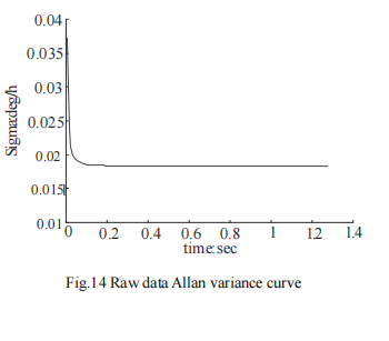
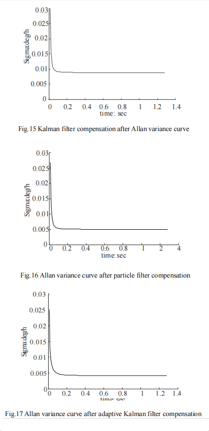
Fig 14 Allen variance curve of raw data

The compensated Allen variance curve

4. Summary
From FIG. 14 to FIG. 17, it can be seen that the Allan variance program of the paper can effectively analyze the experimental data.
Several sets of experimental data show that the program is effective.

Different algorithm compensation results

After analyzing the data before and after compensation, it can be seen that the quantization noise and zero bias instability noise of the data after compensation by Kalman filter algorithm are reduced by 64% and 66.4% respectively. The quantization noise and zero bias instability noise of the compensated particle filter data are reduced by 70% and 72.1% respectively. The quantization noise and zero bias instability noise of the data compensated by adaptive Kalman filter are reduced by 91.5% and 75.7% respectively. All the algorithms we mentioned can have a better compensation effect for the original data noise.
It can be seen from the compensation effect that compared with traditional Kalman filter and particle filter, adaptive Kalman filter can better remove the noise in the original data, and filter the noise of ER-EC-385ER-EC-365B and other types of electronic compass. The random data in the simulation experiment is based on the simulation of the noise caused by soft magnetic interference. The simulation results show that the filtering algorithm can compensate the noise of soft magnetic interference. 

Thursday, February 22, 2024

Soft Magnetic Error Compensation Method of Electronic Compass


1. Analysis of soft magnetic error of electronic compass

There is another ferromagnetic substance in the working environment of the electronic compass sensor, which, unlike hard ferromagnetic materials, is easily magnetized in a weak magnetic field. When the external magnetic field changes, its induced magnetism will also undergo a related change. The size and direction of the induced magnetic field will also change with the attitude and position of the carrier.
Because of its special properties, this material is called soft iron material. This soft iron material magnetizes itself due to the size of the external magnetic field it receives to produce a magnetic field that resists changes in magnetic flux, which can vary over a wide range. If the magnetic field in the space where the electronic compass sensor is located is known, the magnetic field actually measured by the electronic compass sensor is equal to the superposition of the geomagnetic field and the magnetic field generated by the soft iron interference. The soft iron error is equivalent to a time-varying error superimposed on the output of the electronic compass sensor. Because of the different properties of soft magnetic interference error and hard magnetic interference error, the least square method is no longer applicable when compensating soft magnetic interference error. Soft magnetic interference will lead to the deviation of the measurement Angle of the electronic compass. In an ideal environment, the Angle rotated by the measurement of the electronic compass is controllable, but the existence of soft magnetic interference error will lead to the deviation and uncontrollable Angle of the measurement process of the electronic compass. In the application of navigation system, a small Angle difference will lead to a large route error. The modern electronic compass has strong anti-interference and can suppress most of the Angle deviation, but the compensation of soft magnetic error is still worth studying and discussing.

2. Soft magnetic interference error compensation method
In the actual use of electronic compass, the noise errors caused by soft magnetic interference are mostly random noise errors. At present, there are many algorithms that can be used to compensate random noise and most of them are relatively mature, but considering the characteristics of electronic compass requiring real-time and rapid processing of large amounts of data. Three very mature random noise compensation algorithms, namely Kalman filter, improved Sage adaptive Kalman filter and particle filter, are selected as soft magnetic interference compensation algorithms. These three algorithms are easy to implement and can handle dense data.

2.1 Kalman filter
Kalman filtering algorithm can estimate the linear system with Gaussian white noise, which is the most widely used filtering method at present, and has been well applied in the fields of communication, navigation, guidance and control. The basic idea is that the minimum mean square error criterion is the best estimation criterion, and the future state quantity of the system is estimated by recursion theory, so that the estimated value is as close as possible to the real value.

2.2 Adaptive Kalman filtering
Traditional Kalman filter requires that the mean of dynamic noise and observed noise of the system be zero, and the statistical characteristics are known white noise, but these conditions may not be satisfied in practice, so there are modeling errors. Due to the limitation of objective conditions such as computing tools, the filtering algorithm is easy to produce error accumulation when running on the computer. This results in the loss of positivity or symmetry of error covariance matrix and the instability of numerical calculation.

2.3 Particle filter algorithm
The particle filter algorithm originated from the research of Poor Man's Monte Carlo problem in the 1950s, but the first applied particle filter algorithm was proposed by Gordon et al in 1993. The particle filter is based on the Monte Carlo method, which uses sets of particles to represent probabilities and can be used for any form of state-space model. Particle filter can accurately express the posterior probability distribution based on the observed and controlled quantities, and is a sequential important sampling method. Bayesian inference and importance sampling are the basis of understanding particle filtering.

3. Allan variance simulation experiment 
The Allan analysis of variance is used to simulate the original data of random sequence, the data compensated by Kalman filter algorithm, the data compensated by particle filter algorithm, and the four groups of data compensated by adaptive Kalman filter algorithm. Verify the feasibility of Allan variance analysis algorithm. The Allan standard deviation curve of each data is drawn according to the analysis results. The Allan standard deviation curves of the four groups of data are shown in FIG. 14-17 respectively.

Fig 14 Allen variance curve of raw data

The compensated Allen variance curve

4 Summary
From FIG. 14 to FIG. 17, it can be seen that the Allan variance program of the paper can effectively analyze the experimental data.
Several sets of experimental data show that the program is effective.

Different algorithm compensation results

After analyzing the data before and after compensation, it can be seen that the quantization noise and zero bias instability noise of the data after compensation by Kalman filter algorithm are reduced by 64% and 66.4% respectively. The quantization noise and zero bias instability noise of the compensated particle filter data are reduced by 70% and 72.1% respectively. The quantization noise and zero bias instability noise of the data compensated by adaptive Kalman filter are reduced by 91.5% and 75.7% respectively. All the algorithms we mentioned can have a better compensation effect for the original data noise.
It can be seen from the compensation effect that compared with traditional Kalman filter and particle filter, adaptive Kalman filter can better remove the noise in the original data, and filter the noise of ER-EC-385ER-EC-365B and other types of electronic compass. The random data in the simulation experiment is based on the simulation of the noise caused by soft magnetic interference. The simulation results show that the filtering algorithm can compensate the noise of soft magnetic interference.  

HDD technology breakthrough! North seeker helps with orientation in trenchless construction

  As the core technology of trenchless pipeline laying, HDD technology places extremely high demands on the direction control of the drill b...