Tuesday, November 21, 2023

Is Tilt Sensor Analog or Digital?

 The output mode of the tilt sensor is divided into two types, one refers to the physical output mode, and the other is only the electrical output mode.

How many kinds of physical output modes are there for tilt sensors?

Usually there is a cable output, connector output. Cable output depends on the length, see the color identification. Connector output, pay attention to the number of cores, and pin definition.

What is the electrical output mode of the tilt sensor?

The electrical output mode is relative to the physical output mode, mainly refers to the electrical connection mode of the following bit machine, which is divided into many kinds, the largest is divided into two categories, that is, analog output and digital output.

What is an analog output tilt sensor?

Analog line output means that the output signal is an analog signal, such as voltage output, current output.

1. Voltage output

It is usually 0~5v output, there are also 0.5~4.5v output, and 0~10V output, most of the cases are 0~5V output mode. As far as the current understanding of the situation is concerned, if the upper computer is a PLC controller of Siemens, it may be limited by the shortage or limitation of interface resources, and will use 0~10V output, which will be encountered in the photovoltaic industry. Why develop a 0.5~4.5Vdc output? In special cases, the user wants to determine whether the sensor is normal, if you see 0~0.5V voltage output on the display, as a reference for troubleshooting, you will use 0.5~4.5V output inclination sensor. For example, the ER-TS-3160VO is a single-axis tilt sensor with analog voltage output, and the user only needs to collect the voltage value of the sensor to calculate the tilt angle of the current object. The built-in (MEMS) solid pendulum measures changes in the static gravity field, converts them into changes in inclination, and outputs them via voltage (0~10V, 0.5~4.5V, 0~5V optional).

How many lines are the inclination sensors with voltage output? Single-axis inclination sensor for voltage output: power supply +, power supply -, voltage output 1 way, is three-wire system; For dual-axis voltage output inclination sensor: power supply +, power supply -, voltage output 2, is a four-wire system.

2. Current output

4~20mA output used to be more common, belongs to the more traditional, because the digital circuit is not very popular, but in the last 20 years, the digital circuit has long been popular, so this form is slowly no longer useful, but considering that some controllers, upper computers, secondary instruments and so on have such interfaces, so there are still customers choose this interface, This is the reason for the historical transition, but 4 to 20mA has an advantage, that is, the transmission distance is far, unlike the voltage output, after a longer cable, the signal attenuation is larger.

Although the voltage at the output end is unchanged, the longer the cable, the smaller the voltage to the load end, and the current type output end is the same as the load end, it is impossible to change. Therefore, when your upper computer is more than 50 meters away from the sensor, in order to ensure the stability and reliability of the signal, the output of 4~20mA is one of the choices. The ER-TS-3168CU is a standard industrial current output single-axis tilt sensor that can transmit over a considerable distance, up to 2,000 meters away.

For the inclination sensor with current type output, what is the two-wire system and what is the three-wire system? Look at the following figure, very intuitive, at a glance, Figure 1 is a two-wire system, Figure 2 is a three-wire system. Single-axis two-wire system, two-axis three-wire system, pay attention to the load resistance when in use do not ignore.
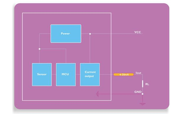
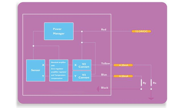
Two-wire current output tilt sensorthree-wire current output tilt sensor


What is a digital output tilt sensor?

Digital output is relative to analog, there are many kinds of digital interfaces, such as RS232,TTL, RS485, CAN, PWM, and very rare RS422 interface, SII interface, and other master-slave communication methods. ER-TS-4156DI is a digital single-axis tilt sensor, its output mode has RS232, RS485 or TTL, MODBUS level interface options, it can resist external electromagnetic interference, adapt to harsh industrial environment for long-term work, is an ideal choice for industrial automation control and platform attitude measurement.

Application areas and uses of IMU

Inertial navigation IMU has a wide range of application scenarios and is often used for pointing, steering and guidance monitoring, rock soil monitoring, etc. in advanced mining/drilling equipment, ships, automobiles, drones, robots, oil exploration, bridge exploration, high-rise buildings, iron towers, dams, etc. , navigation and positioning of transportation vehicles such as mining and missiles, and north-finding positioning in geodetic/land mobile mapping systems.


In the automotive field, inertial navigation IMU can help vehicles achieve autonomous driving and traffic jam identification, improving driving performance and safety. In land vehicles, IMUs can be integrated into GPS-based car navigation systems or vehicle tracking systems to provide dead reckoning capabilities to the system and the ability to collect as much accurate data as possible about the vehicle’s current speed, turn rate, heading and inclination and acceleration, combined with the vehicle’s wheel speed sensor output and reverse gear signal for purposes such as better traffic collision analysis. The ER-MG2-300/400 developed by ERICCO is a navigation-grade MEMS gyro sensor with a measurement range of up to 400 degrees/second and a bias instability of 0.05°/hour. It is designed for precision attitude in high-performance IMU/AHRS. Designed for azimuth measurement, positioning, navigation, guidance/GNSS-assisted INS, aviation/marine/land mapping/measurement systems/unmanned aerial vehicle/AUV and navigation-level MEMS weapon systems.

In the aviation field, inertial navigation IMU can realize motion control such as aircraft climbing, descending, turning, taxiing, etc., improving flight safety and accuracy. In a navigation system, data reported by the IMU is fed into a processor to calculate altitude, speed, and position. ER-MIMU-01 developed by ERICCO uses high-quality and reliable MEMS accelerometer and gyroscope. It communicates with the outside through RS422. The baud rate can be flexibly set between 9600~921600. The communication baud rate required by the user can be set through the communication protocol. Equipped with X, Y, Z three-axis precision gyroscope, X, Y, Z three-axis accelerometer, with high resolution, it can output the original hexadecimal complement of X, Y, Z three-axis gyroscope and accelerometer through RS422 code data (including gyroscope hexadecimal complement) numerical temperature, angle, accelerometer hexadecimal temperature, acceleration hexadecimal complement); it can also output gyroscope and accelerometer data that have been processed by underlying calculations Floating point dimensionless value.

One of the earliest devices was designed and built by the Ford Instrument Company for the U.S. Air Force and was intended to help aircraft navigate in flight without requiring any input from outside the aircraft. The device, known as a ground position indicator, shows the pilot the aircraft’s longitude and latitude relative to the ground once the pilot inputs the aircraft’s longitude and latitude during takeoff.

A major disadvantage of using IMUs for navigation, then, is that they are often subject to cumulative errors. Because the guidance system continuously integrates acceleration versus time to calculate velocity and position (see dead reckoning), any measurement error, no matter how small, accumulates over time. This results in “drift”: an increasing discrepancy between where the system thinks it is and where it actually is. The ER-MG-067 developed by ERICCO is a high-precision tactical-grade MEMS gyroscope with an instability deviation of 0.3 degrees/hour and an angular random walk of 0.125°/√h. It is a single-axis MEMS angular rate sensor. (gyroscope), capable of measuring angular velocity up to ±400°/s, and the digital output complies with the SPI slave mode 3 protocol. Angular rate data is represented as 24-bit words.

If you want to know more about imu's products, please click the link below to contact us, and we will have professional personnel connect with you.

Web:https://www.ericcointernational.com/inertial-measurement-units

Email: info@ericcointernational.com

Whatsapp: 13630231561

WeChat13992884879


Monday, November 20, 2023

The smallest North Finder you've ever seen

 The dimensions are only 44.84×38.88×21.39mm and the weight is 60g. The north-seeking accuracy can reach 0.25°~1°, and the update rate is 200Hz. It has the advantages of high precision, light weight and low power consumption, and can quickly and independently determine the true north direction. Compared with other MEMS north seekers, it not only improves the sensitivity of the sensor and reduces errors, but also makes its power supply only support 5±0.25V and the power is 2W. The MEMS gyroscope used has a bias instability of 0.02°/hr and an angular random walk of 0.005°/√hr, which can meet the needs of medium and high-precision measurements, and is small enough for devices with high space and power consumption requirements.

It can be used in directional drilling rigs and deep hole drilling rigs, which can help find the true north direction in coal mines, improve work efficiency, and tunnel boring machines in coal mining to improve the quality of coal mining.

At the same time, it can also be used in radar vehicles and military rocket launch vehicles, which is very helpful in improving the orientation and alignment of rocket launches.

In the field of surveying and mapping vehicles, it can be directly installed on the surveying and mapping vehicle. For static north seeking, you can choose the 01 model for high-precision dynamic north seeking.

Rock drills and tunnel construction can also apply north-seeking technology.

It is not only widely used in high-tech defense fields such as satellites, missiles, and high-precision inertial navigation system initial alignment, but also widely used in geophysical exploration, coal mining, geodesy, mining, underground drilling projects, tunnels and other fields. Excavation, as well as civilian fields such as unmanned vehicle automatic driving systems and vehicle positioning and navigation systems.

If you have any opinions about northfinder , welcome to leave your comments and share with your friends. If you are interested in the northseeker products, you can send message to me or send email to info@ericcointernational.com

Contact us:

WeChat: 13992884879

WhatsApp: 13630231561


Application of Tilt Sensor in Hydraulic Tipping and Unloading Machine


 Tilt sensors can be used in hydraulic tipping and unloading machine, you know?

The hydraulic tipping machine is a kind of unloading device which can automatically unload the bulk material by turning the semi-mounted truck over or over. The large mechanical equipment used to unload the railway open car, the machinery that can flip or tilt the rail vehicle to achieve discharge, is mostly used in the port with a large traffic volume and the industrial sectors such as metallurgy, coal, and thermal power. It is also used under the mine, but mostly for small tipper; Bulk materials mainly refer to grain, feed, cement, coal, ore, mineral powder and so on. This unloading machine is widely used in grain stations, feed mills, warehousing, ports, mines, chemical industry, iron and steel factories and other enterprises. Suitable for high temperature, dust and other places. High efficiency, save manpower.

The hydraulic control valve is load-sensitive proportional multi-way valve. The speed can be adjusted arbitrarily, the process of dumping grain over the plate can be controlled, and there is no power output when there is no action. Compact structure, modular, easy to replace. P, Q follow function.

The electronic control part is controlled by PLC, equipped with a touch screen to realize the monitoring and control mode switch of the system, with remote control operation, the control part is simple, the use of ER-TS-4150VO tilt sensor to automatically level, anti-tilt, to achieve automatic correction function, leveling accuracy up to +0.1°, when the tilt of the horizontal direction of the flip plate can be automatically corrected;

The limit switch of the unloading machine has the function of travel limit, safety lock and manual playback. In the event of power failure or misoperation, the equipment will be locked in the current position to prevent the danger caused by misoperation. However, whether the limit switch is installed in the correct position and deformed, long-term use will have mechanical damage, and the angle sensor can be used to ensure that the angle is determined, which can ensure the accuracy of the angle to check whether there is a large amount of ash accumulation between the drive gear and the rotary support rod.

If you want to learn more about MEMS tilt sensors or buy tilt sensors

Please contact me in the following ways:

Email: info@ericcointernational.com

Whatsapp: 173 9198 8506

What is the use of Quartz Flexible Accelerometer

 Quartz flexible accelerometer,as the main type of accelerometer used to measure the acceleration of the carrier, is a very important inertial device. Although the trajectory of the object can be obtained by measuring the acceleration, speed or position in the navigation and positioning of various carriers, the quartz flexible accelerometer is of great significance for inertial navigation technology because only the acceleration can be measured inside the moving object.

The application of quartz flexible accelerometer is very wide, the following are some typical applications of it.

Inertial navigation and guidance system

Missiles, aircraft, ships, combat vehicles, and other navigation guidance systems must have speed and position information. In low-requirement situations, people use airspeed meters, Mach number sensors, odometers, but as the performance requirements of weapon systems Improve, the above instruments can no longer meet the requirements. The linear accelerometer can be installed in a moving object to measure its acceleration directly, and then obtain the speed and position. It has high measurement accuracy and good dynamic performance, which is much better than the air speed meter and odometer. Therefore, the use of linear accelerometers for inertial navigation guidance systems is one of its main applications.ER-QA-03A as an example,its bias repeatability is 10-50μg,scale factor repeatability is 15-50 ppm and class II non-linearity repeatability is10 to 30 mu g/g2.

Tilt measurement and leveling system

In a gravitational field, a linear accelerometer can measure changes in gravitational acceleration. When the sensitive axis is perpendicular to the horizontal plane, the accelerometer indicates the unit gravity acceleration; if the sensitive axis is tilted, its output is the product of the gravity acceleration and the sine function of the tilt angle. Using this principle, it can be used for tilt measurement and leveling. For example, the leveling of fire control gun sight radar and anti-aircraft radar; in addition, the tilt angle is controlled by measuring the lateral acceleration of trains and cars so that they can still drive at high speeds on curves. For example,the bias stability of


ER-MA-5 is (1s standard deviation)(1σ)<20ug, and bias month repeatability is 200ug.

If you want to know more about quartz accelerometers or purchase, please contact me through the following ways:

Email : info@ericcointernational.com

Web: https://www.ericcointernational.com/accelerometer/quartz-accelerometer


Sunday, November 19, 2023

How is IMU used?

The concept of IMU

The inertial measurement unit, referred to as IMU, is a device that measures the three-axis attitude angle (or angular velocity core) and acceleration of an object. Gyroscopes and speedometers are devices of an inertial navigation system.

The IMU has a built-in speed sensor and gyroscope, which can measure linear acceleration and rotational angular velocity in three directions.

Working principles for IMU

IMU is based on Newton’s laws of mechanics. By measuring the acceleration of the carrier in the inertial reference system, integrating it over time, and transforming it into the navigation coordinate system, the speed and yaw angle in the navigation coordinate system can be obtained. and location information.

The inertial measurement unit is a device that measures the three-axis attitude angle (or angular rate) and acceleration of an object. Generally, an IMU contains three single-axis accelerometers and three single-axis gyroscopes. The accelerometer detects the acceleration signals of the object in three independent axes of the carrier coordinate system, while the gyroscope detects the angular velocity signal of the carrier relative to the navigation coordinate system, and measures the object’s position in the carrier coordinate system. The angular velocity and acceleration in three-dimensional space are used to calculate the attitude of the object. It has very important application value in navigation.

The principle of an inertial measurement unit is very similar to taking small steps in the dark. In the dark, due to the error between your estimate of the step length and the actual distance walked, as you take more and more steps, the difference between your estimated position and the actual position will become farther and farther. When taking the first step, the estimated position is relatively close to the actual position; but as the number of steps increases, the difference between the estimated position and the actual position becomes larger and larger. This method is extended to three dimensions, which is the principle of the inertial measurement unit.

Therefore, in layman’s terms, the inertial measurement unit IMU is a strapdown inertial navigation system. The system consists of three acceleration sensors and three angular velocity sensors (gyros). The accelerometer is used to feel the acceleration component relative to the vertical line of the ground. The speed sensor is used to get a feel for the angle information.

It is worth noting that the inertial measurement unit provides relative positioning information. Its function is to measure the movement route of the object relative to the starting point, so it cannot provide information about your specific location. Therefore, it is often combined with GPS. Used together, when the GPS signal is weak in some places, the IMU can play its role, allowing the car to continue to obtain absolute position information and not get “lost.”

How three-axis accelerometer works

Most three-axis acceleration sensors use piezoresistive, piezoelectric and capacitive operating principles. The resulting acceleration is proportional to changes in resistance, voltage and capacitance and is collected by corresponding amplification and filtering circuits. This is the same principle as an ordinary acceleration sensor, so through certain technology, three single axes can be turned into a three-axis. For most sensor applications, a two-axis acceleration sensor is sufficient.

Working principle of three-axis gyroscope

The working principle of the three-axis gyroscope is based on the gyro effect. When the gyroscope’s axis of rotation is perpendicular to the direction of the force, it feels the force, which creates a torque that causes it to rotate in the coordinate system. The three gyroscopes in a three-axis gyroscope are mounted on three mutually perpendicular axes. They sense the angular velocity on the x, y, and z axes respectively, and output the signals to relevant circuits for processing.

Application areas and uses of IMU

Inertial navigation IMU has a wide range of application scenarios and is often used for pointing, steering and guidance monitoring, rock soil monitoring, etc. in advanced mining/drilling equipment, ships, automobiles, drones, robots, oil exploration, bridge exploration, high-rise buildings, iron towers, dams, etc. , navigation and positioning of transportation vehicles such as mining and missiles, and north-finding positioning in geodetic/land mobile mapping systems.

In the automotive field, inertial navigation IMU can help vehicles achieve autonomous driving and traffic jam identification, improving driving performance and safety. In land vehicles, IMUs can be integrated into GPS-based car navigation systems or vehicle tracking systems to provide dead reckoning capabilities to the system and the ability to collect as much accurate data as possible about the vehicle’s current speed, turn rate, heading and inclination and acceleration, combined with the vehicle’s wheel speed sensor output and reverse gear signal for purposes such as better traffic collision analysis. The ER-MG2-300/400 developed by ERICCO is a navigation-grade MEMS gyro sensor with a measurement range of up to 400 degrees/second and a bias instability of 0.05°/hour. It is designed for precision attitude in high-performance IMU/AHRS. Designed for azimuth measurement, positioning, navigation, guidance/GNSS-assisted INS, aviation/marine/land mapping/measurement systems/unmanned aerial vehicle/AUV and navigation-level MEMS weapon systems.

In the aviation field, inertial navigation IMU can realize motion control such as aircraft climbing, descending, turning, taxiing, etc., improving flight safety and accuracy. In a navigation system, data reported by the IMU is fed into a processor to calculate altitude, speed, and position. ER-MIMU-01 developed by ERICCO uses high-quality and reliable MEMS accelerometer and gyroscope. It communicates with the outside through RS422. The baud rate can be flexibly set between 9600~921600. The communication baud rate required by the user can be set through the communication protocol. Equipped with X, Y, Z three-axis precision gyroscope, X, Y, Z three-axis accelerometer, with high resolution, it can output the original hexadecimal complement of X, Y, Z three-axis gyroscope and accelerometer through RS422 code data (including gyroscope hexadecimal complement) numerical temperature, angle, accelerometer hexadecimal temperature, acceleration hexadecimal complement); it can also output gyroscope and accelerometer data that have been processed by underlying calculations Floating point dimensionless value.

One of the earliest devices was designed and built by the Ford Instrument Company for the U.S. Air Force and was intended to help aircraft navigate in flight without requiring any input from outside the aircraft. The device, known as a ground position indicator, shows the pilot the aircraft’s longitude and latitude relative to the ground once the pilot inputs the aircraft’s longitude and latitude during takeoff.

A major disadvantage of using IMUs for navigation, then, is that they are often subject to cumulative errors. Because the guidance system continuously integrates acceleration versus time to calculate velocity and position (see dead reckoning), any measurement error, no matter how small, accumulates over time. This results in “drift”: an increasing discrepancy between where the system thinks it is and where it actually is. The ER-MG-067 developed by ERICCO is a high-precision tactical-grade MEMS gyroscope with an instability deviation of 0.3 degrees/hour and an angular random walk of 0.125°/√h. It is a single-axis MEMS angular rate sensor. (gyroscope), capable of measuring angular velocity up to ±400°/s, and the digital output complies with the SPI slave mode 3 protocol. Angular rate data is represented as 24-bit words.

If you want to know more about imu's products, please click the link below to contact us, and we will have professional personnel connect with you.

Web:https://www.ericcointernational.com/inertial-measurement-units

Email: info@ericcointernational.com

Whatsapp: 13630231561

WeChat13992884879


What is the Function of a Tilt Sensor in a Robot?


How tilt sensors work in robots, let's take a look.

A robot is a machine that performs work automatically. It can either be directed by humans, run pre-programmed programs, or act according to principles laid down by AI technology. Its mission is to help replace human jobs, such as manufacturing, construction, or dangerous jobs. The inspection robot is one of them. It carries a visible light camera, infrared thermal camera, pickup, ultrasonic wave, inclination sensor, etc. At the same time, it adopts trajectory navigation and can conduct autonomous or remote control inspection of outdoor high-pressure equipment according to the optimal path planning. Through machine vision, infrared temperature measurement, sound detection and other methods, the inspection robot can collect infrared heat map, image and audio information of the equipment. It also automatically identifies the thermal defects, abnormal appearance, switch or tool position, instrument reading, and oil level meter position of the equipment, generates unified and standardized alarm items and inspection reports, sends alarm information to the operator, and provides basic data for equipment status maintenance. In unattended, less attended substations or smart substations, especially in plateau, low oxygen, high cold and other geographical conditions or bad weather conditions, inspection robots can replace or assist manual inspection of substation equipment.

When the inspection robot is crossing obstacles, the partial moment caused by mass eccentricity damages the horizontal posture of the robot body. In order to ensure its smooth progress, a simple and reliable centroidness adjustment method is needed. The tilt sensor ER-TS-4258CU is used to measure the inclination angle between the robot body and the horizontal plane, so as to control the movement of the mobile motor of the counterweight block. When the center of mass of the robot is adjusted to the arm suspended on the overhead ground wire, the measurement angle should be controlled within the range of 90° with an accuracy of ±0.1°, so as to ensure that the robot body maintains a horizontal posture and ensure that the arm that needs to be off-line or online completes the corresponding action. Finally, the feasibility of the centroid control method is verified by simulation experiments.

If you want to learn more about MEMS tilt sensors or buy tilt sensors

Please contact me in the following ways:

Email: info@ericcointernational.com

Whatsapp: 173 9198 8506

High-precision IMU is coming to help in the fields of land, sea and air

  High-precision IMU is now widely used in many fields of sea, land and air. It can provide real-time and accurate information on the carrie...