Thursday, January 4, 2024

IMU algorithm: data acquisition & calculation of speed and direction

IMU algorithm: data acquisition & calculation of speed and direction

North-Seeking MEMS IMU

The IMU algorithm refers to the inertial navigation system algorithm, which is used to estimate the speed and direction of an object based on data collected by inertial sensors (gyros and accelerometers). To use the IMU (Inertial Measurement Unit) algorithm to calculate speed and direction, data from the accelerometer and gyroscope need to be combined. The following will explain in detail the calculation of objects and speeds from collected data and the IMU algorithm.

Data acquisition and speed and direction calculation stepsData collection

The IMU algorithm works based on data collected by gyroscopes and accelerometers. Gyroscopes can measure the rotation speed of an object in three axes, while accelerometers can measure the acceleration of an object in three axes. This data is used to calculate the object’s attitude (pitch, yaw, and roll angles) and velocity.

  • Attitude calculation: The IMU algorithm calculates the attitude of the object through gyroscope data. Use quaternions or Euler angles to represent the attitude, and calculate the rotation angle and rotation axis of the object through continuous-time quaternions or Euler angles. By comparing the poses of the current frame and the previous frame, the rotation speed and angular speed of the object in three-dimensional space can be calculated.
  • Speed calculation:The IMU algorithm calculates the speed of an object through accelerometer data. Objects will be affected by gravity when they move, and the components of gravity acting in different directions can be expressed as g. Therefore, the gravity component can be calculated from the acceleration measured by the accelerometer, and then the velocity and displacement of the object can be obtained through integration. At the same time, since changes in the attitude of the object will produce changes in inertia, the angular velocity of the object can be obtained through gyroscope data, and the rotation angle and rotation axis of the object can be obtained through integration.
  • Fusion algorithm: In order to improve the accuracy and stability of the IMU algorithm, a fusion algorithm can be used to fuse sensor data such as gyroscopes, accelerometers and magnetometers. The fusion algorithm can use algorithms such as Kalman filter, complementary filter or Madgwick filter. By fusing data from different sensors, more accurate speed and direction information can be obtained.

2.Data preprocessing:In order to get more accurate results, you may need to perform some preprocessing on the original data, such as filtering or denoising. This can be achieved with various digital filters such as Kalman filters.

3.Calculate the accelerometer offset: Due to the Earth’s gravity, the accelerometer will read a constant offset even if the device is stationary. To eliminate this offset, the accelerometer’s offset needs to be updated periodically.

4.Calculate the angular velocity deviation:Similarly, the gyroscope may also have an initial deviation due to various reasons (such as errors during startup). This deviation can be estimated by comparing rotation angles over time and updated periodically.

5.Calculate speed and direction: Once you have the bias-corrected acceleration and angular velocity data, you can use these data to calculate speed and direction. For velocity, this can be found by integrating angular velocity; for direction, it can be found by integrating acceleration (but this usually results in cumulative errors, so more sophisticated methods such as magnetometers or GPS assistance may be needed).

6.Compensate for the effects of the Earth’s rotation:The Earth’s rotation also creates a small rotational moment on the device, which affects orientation calculations. To eliminate this effect, it may be necessary to use some method to track the speed of the Earth’s rotation and take this into account when calculating the direction.

7.Integrate other sensor data: To improve accuracy, you can also consider integrating other sensor data, such as magnetometers or GPS. A magnetometer can provide a device’s absolute orientation relative to the Earth’s magnetic field, while GPS can provide a device’s precise location and timestamp, which is particularly useful for long-distance navigation.

Brief description of IMU algorithm

The IMU (Inertial Measurement Unit) algorithm is a complex system used to calculate speed and direction by combining data from accelerometers and gyroscopes. And collect its data and add it to the algorithm to output the attitude angle and speed information of the device. The following is a more detailed IMU algorithm process. This part will explain the above content in more detail.

1.Data collection:

IMUs typically contain accelerometers and gyroscopes. Accelerometers measure acceleration, while gyroscopes measure angular velocity. Data acquisition is accomplished through a microcontroller or computer, which periodically reads and stores the IMU sensor measurements.

2.Data preprocessing:

Due to the existence of noise and outliers, data denoising and filtering are required. Commonly used filters include the Kalman filter in Figure 1 and the complementary filter in Figure 2, which can combine accelerometer and gyroscope data to provide more accurate results.

                                                                                         Figure1: Kalman filter

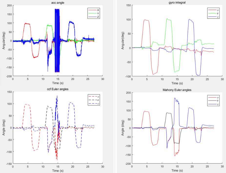
                                                                                    Figure2:complementary filter

3.Accelerometer deviation compensation:

The accelerometer is affected by the Earth’s gravity when stationary, which causes a fixed bias in the measurement results. By comparing acceleration measurements over time, this bias can be estimated and compensated for.

4.Gyroscope deviation compensation:

The gyroscope may have an initial bias when it starts up, which affects the angular velocity it measures. This deviation can be estimated and compensated for by comparing angular velocity measurements over time.

5.Speed calculation:

Use integrated angular velocity to calculate the angle of rotation. By integrating the angular velocity twice, you get the velocity. This requires knowing the initial velocity and initial position.

6.Direction calculation:

Use integrated acceleration to calculate direction. But this approach can lead to cumulative errors because the Earth’s rotation affects the device’s orientation. To improve accuracy, corrections can be made in conjunction with data from other sensors such as magnetometers or GPS. A magnetometer can provide a device’s absolute orientation relative to the Earth’s magnetic field, while GPS can provide a device’s precise location and timestamp.

7.Kalman filter application:

The Kalman filter (Figure 1) is an optimization algorithm used to combine data from multiple sensors to provide more accurate results. It uses mathematical models to predict sensor measurements and updates the predictions with new measurements. In IMU applications, the Kalman filter can be used to fuse accelerometer and gyroscope data to provide more accurate attitude angle (pitch, yaw and roll angle) and velocity information.

  • Pitch angle θ (pitch): rotates around the X-axis.
  • Yaw angle ψ (yaw): Angle of rotation around the Z-axis.
  • Roll angle Φ (roll): The angle of rotation around the Y axis.

                                                                                       Attitude angle diagram

8.Output:

After the above steps, the IMU algorithm can output the attitude angle and speed information of the device. This information can be used in a variety of applications such as drone control, robot navigation, and motion tracking.

It should be noted that the implementation of the IMU algorithm involves complex mathematical operations and sensor fusion technology. In actual applications, further adjustments and optimizations may be required to adapt to different application scenarios and hardware devices.

Conclusion:

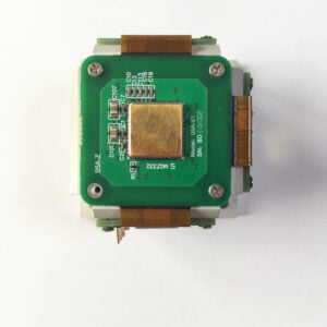
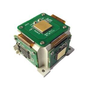
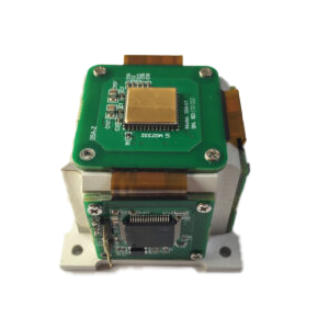
The above article briefly describes a detailed algorithm of IMU from data collection to speed and direction calculation. Through the processing and analysis of gyroscope and accelerometer data, the attitude, speed and direction information of the object can be obtained. In order to improve the accuracy and stability of the algorithm, a fusion algorithm can be used to fuse multiple sensor data. It is through this method that Ericco Inertial System. calculates the speed and direction of the IMU, which can more accurately measure the direction of the object. Your company is also constantly developing independently higher-precision IMUs. So far, ERICCO has developed Two types of IMU: MEMS IMU and FOG IMU. For example, the navigation-level ER-MIMU01 and ER-MIMU05 can independently seek north without relying on a magnetometer or GNSS. The accuracy of the gyroscope is also relatively high, the angular velocity random walk is less than 0.005, and the bias stability is less than 0.1°/h. Compared with other companies’ products, it has great advantages and higher accuracy.

ERICCO’s MEMS IMUs are divided into navigation-level and tactical-level. Compared with many top-ranking system companies, the biggest advantage of navigation-level IMUs is that they can independently seek north, which many large companies cannot achieve with MEMS IMUs. And they better reflect the inherent characteristics of MEMS IMU: small size, high performance, low cost, light weight and other characteristics. The most important thing is that these characteristics allow them to be produced in large quantities. This is relatively friendly to customers with high demand. If you want to know more about or purchase IMU products, please contact our technical staff.


Contact me

Websitehttps://www.ericcointernational.com/inertial-measurement-units

Email: info@ericcointernational.com

WhatsApp: +8613992884879

Wednesday, January 3, 2024

What are Three Examples of Ways to Use a Tilt Sensor?


 Tilt sensor is a sensor used to measure the tilt angle of an object relative to the horizontal plane. It can accurately and real-time monitor and record the change of tilt angle, which provides important data support for various industrial applications and scientific research fields.

1. Bridge monitoring

Bridges are an important part of urban traffic, and their stability and safety are crucial to the normal operation of the city. In order to ensure the safety of the bridge, it is necessary to monitor its structure in real time. Tilt sensor can be used to monitor the tilt angle of bridge and provide real-time data support for structural safety. By installing tilt sensors at key parts of the bridge, the tilt angle can be continuously monitored and the data can be transmitted to the control center for analysis. Once abnormal conditions are found, timely measures can be taken for maintenance and reinforcement, thus ensuring the safe use of the bridge. For example, ER-TS-3160VO can be installed in the key part of the bridge to monitor the change of the tilt angle of the bridge, its accuracy is 0.01°, the measurement range is 0~±180°, and the measured value can be output by 0~10V, 0.5~4.5V, 0~5V voltage, which is very suitable for bridge, dam and other monitoring projects.

2. Construction machinery

Excavator — In order to realize the three-dimensional spatial positioning of the excavator, on the basis of installing the angle sensors of each joint of the working device, the platform rotation angle detection device and the platform inclination sensor are installed, and the laser receiver is installed on the bucket rod to detect the height of the horizontal mechanism emitted by the ground laser transmitter relative to the zero position of the receiver. The kinematics model of the excavator is established, and the coordinate transformation matrix of the car body relative to the earth is derived, that is, the car body positioning in three-dimensional space is completed, and the commonly used simple car body elevation positioning formula is obtained, so as to realize the three-dimensional space positioning of the excavator’s excavation trajectory and lay the foundation for realizing the accuracy of the excavator’s three-dimensional space trajectory and the excavator’s depth control.

Other heavy industrial machinery – in addition to excavators, in other heavy industrial machinery, including cranes, lifts, graders, etc., will use tilt sensors, and tilt sensors have a heavy and heavy role in these heavy machinery equipment. It not only ensures that the angle range of these mechanical equipment is within the safety, but also can be raised to the alarm if it is out of range to protect personal safety. For example, the tilt sensor in the retractable robot arm is used to measure the attitude of the cab and the change of the tilt angle of the boom to ensure driving safety. ER-TS-4258CU has strong resistance to external electromagnetic interference and is suitable for long-term work in harsh industrial environments. It can be installed in the retractable arm of the construction machinery, and can measure the attitude of the cab and the tilt angle of the boom in real time, which can ensure the driving safety to the greatest extent.

3. Platform control

Shipborne horizontal platform – The inclination sensor is applied on the shipborne horizontal platform, which is used for shipborne satellite to track the base of the antenna to keep the antenna in a horizontal state at all times, and for real-time control of the platform, which can isolate the pitch and roll motion of the hull and make the platform level.

In addition, the inclination sensor is also applied in the launching process of the ship air bag, and is applied to the hook swing of the large pipe laying ship for monitoring and adjustment.

Application of inclination sensor in automatic levelling system of reference plane of large optoelectronic equipment. The dip angle sensor installed on the base detects the dip angle and direction of the reference plane, converts the angle into the elongation of several mechanical legs according to the leveling algorithm, and drives the elongation of the mechanical legs to make the reference plane level.  

Resolution and Accuracy of Tilt Sensors


Accuracy and resolution of tilt sensors

Resolution refers to the sensor in the measurement range can detect and resolve the smallest change in the measured value. The accuracy refers to the error between the angle measured by the sensor and the real angle.

The relationship between precision and resolution with examples 

Take the familiar vernier calipers. We often say that the accuracy of the vernier caliper is 0.1mm, in fact, this statement is not correct, it should be said that the resolution of the vernier caliper is 0.1mm. That is, when the change in length is 0.1mm, Can our eyes see it, tell it apart. The accuracy of the vernier caliper, because the accuracy represents the difference between the measured value and the true value, the accuracy is related to many factors. For example, temperature causes thermal expansion and contraction, when we see a change of 0.1mm, the real may be 0.09mm, such as the caliper bending, or the caliper engraving line is not particularly uniform, will lead to poor accuracy, but the resolution is still 0.1mm. To improve the accuracy of the measurement, we must first improve the resolution of the measurement, if the resolution can not be distinguished, then the accuracy from where to start. Resolution is the limit of accuracy, improve the resolution at the same time to eliminate the impact of other factors on the accuracy, in order to effectively improve the final accuracy.

The angle sensor based on acceleration principle is illustrated in detail. It is the measurement of gravitational acceleration on the sensitive axis of the acceleration sensor into angle data, that is, the angle value and the acceleration value into a sine relationship.

The resolution of tilt sensors are also often referred to as sensitivity. It is mainly caused by the noise of the sensor. The noise equivalent angular change is called the angular resolution. Because the size of the noise is related to the frequency response, the higher the frequency response, the greater the noise. The resolution of the sensor can be improved effectively by taking effective measures to suppress the noise. After the resolution is improved, there is a chance to compensate for the adverse impact of other factors on the accuracy.

Resolution accuracy of vernier calipers

Other factors affecting the accuracy of tilt sensors

Of course, there are many factors that affect the accuracy of tilt sensors, in addition to the most important resolution, but also include:

Zero bias–depending on the characteristics of the core sensitive device itself, it means that the sensor in the absence of angle input (such as absolute horizontal plane), the sensor measurement output is not zero, the actual output angle value is zero bias.

Nonlinearity— can be corrected later, depending on the number of correction points. The more correction points, the better the nonlinearity.

Horizontal axis error— refers to the error caused by coupling to the output signal of the sensor when the sensor applies a certain acceleration perpendicular to its sensitive axis or tilts at a certain angle.

Input shaft non-alignment – refers to the installation deviation of the sensor in the actual installation process, which actually includes the input shaft non-alignment and vertical shaft non-alignment errors.

Sum up

We use specific tilt sensors products to look at the relationship between resolution and accuracy, for example, our ER-TS-12200-Modbus, from the main parameters can be seen, its resolution is 0.0005°, that is, within the measurement range of ±30° can detect and distinguish the smallest change value measured is 0.0005°, the resolution is quite high. The comprehensive accuracy within the full temperature of -40~85° can reach 0.001°, because its resolution has been improved a lot, so its accuracy is naturally improved. 

Resolution and accuracy of High Precision Wireless Transmission Tilt Sensor

In the following figure, the main parameters of ER-TS-3160VO Low cost Voltage Type Single Axis Tilt Sensor, in different measurement ranges, its resolution is not the same, at ±10° its resolution can reach 0.001°, the accuracy is 0.01°. By comparing the parameters of these two products, we can see a relationship between resolution and accuracy. The resolution is low, the accuracy is relatively low, if the resolution is improved, the accuracy will be improved accordingly.

Resolution and accuracy of Low Cost Voltage Type Single Axis Tilt Sensor

Brief Introduction of Accelerometer


 An accelerometer is an instrument that measures acceleration. Acceleration measurement is an important subject in engineering technology. When the object has a large acceleration, the object and the instruments and equipment carried by it and other objects without relative acceleration are subjected to forces that can produce the same large acceleration, that is, dynamic loads. To know the dynamic load, you need to measure the acceleration.

There are many types of accelerometers. Micro-mechanical accelerometers, also known as silicon accelerometers, are now widely used. The principle of sensing acceleration is the same as that of general accelerometers. According to the different reading elements, micro-mechanical accelerometers are classified into piezoresistive accelerometers, capacitive accelerometers, resonant beam accelerometers, and electrostatic force balanced accelerometers. The micro-mechanical accelerometer is small in size, easy to install, simple in measurement method, low in cost and strong in anti-overload capability, and satisfies the requirements for the structure and space limitation of the micro-mini aircraft.

Accelerometers consist of test masses (also called sensitive masses), supports, potentiometers, springs, dampers, and housings.  The detected mass is constrained by the support and can only move along the axis, which is often called the input axis or the sensitive axis. According to the number of input shafts, there are single-axis, dual-axis and triaxial accelerometers.

With the development of MEMS technology, inertial sensor is one of the most widely used MEMS devices, and micro-accelerometer is an outstanding representative of inertial sensor. The theoretical basis of the microaccelerometer is Newton’s second law, according to the basic principles of physics, within a system, the speed cannot be measured, but its acceleration can be measured. If the initial velocity is known, the linear velocity can be calculated by integrating, and the linear displacement can then be calculated. Combined with a gyroscope (used to measure angular velocity), the object can be precisely positioned. The high-precision MEMS accelerometer ER-MA-5 has a bias stability of 5 ug and a monthly bias repeatability of 100-300 ug.

Application

Car safety system

Accelerometers play an important role in automobile safety system. For example, when a car is in a collision, the accelerometer can detect changes in the vehicle’s acceleration and send signals to the airbag system to inflate it at the appropriate time, protecting the driver and passengers. In addition, accelerometers can also be used in vehicle stability control systems to help vehicles in emergency situations. Keep it steady.

Aerospace

Accelerometers are also widely used in the aerospace field. During a rocket launch, for example, an accelerometer can measure changes in the rocket’s acceleration to help control the trajectory of the rocket. In addition, the accelerometer can also be used in the aircraft’s autopilot system to help maintain stability.For example, the ER-QA-03A accelerometers commonly used in the aerospace field have a  bias stability of 10-50μg, and the Scale factor repeatability is 15-50ppm.

The existing problems and development trend 

The advancement of MEMS technology and the improvement of technological level also bring new opportunities to the development of micromechanical accelerometers. By understanding the research dynamics of micromechanical accelerometers at home and abroad, there are several development trends of micromechanical accelerometers in the future:

1. The  micromechanical  accelerometer with high resolution and large range has become the focus of research. Because the inertial mass block is relatively small, the inertial force used to measure acceleration and angular velocity is correspondingly small, and the sensitivity of the system is relatively low, so it is particularly important to develop a high-sensitivity accelerometer.

2. The development of multi-axis accelerometers has become a new direction. The inertial measurement combination has six output variables, three of which are mutually positive accelerations on the X, Y, and Z axes. There have been literature reports on the development of triaxial micro-silicon accelerometers, and the methods used are different, but its performance is still a long way from practical, and the structural design of multi-axis accelerometers is still a difficult point.

3. small temperature drift, small hysteresis effect has become a new performance target. The accuracy of micromachined accelerometers can be greatly improved by selecting suitable materials, adopting reasonable structure and applying new low-cost temperature compensation link.

If you want to get more details about quartz-accelerometer, pls visit https://www.ericcointernational.com/accelerometer/quartz-accelerometer/

For more information, please feel free to contact info@ericcointernational.com

Tuesday, January 2, 2024

Easy to Understand IMU Explanation


Low-cost Attitude-control MEMS IMU

IMU is the abbreviation of Inertial Measurement Unit. It is a sensor composed of an accelerometer, a gyroscope and a magnetometer, which is used to measure the motion status of an object such as angle, speed and acceleration. The accelerometer is used to measure the object’s acceleration and gravity, the gyroscope is used to measure the object’s angular velocity and gravity, the gyroscope is used to measure the object’s angular velocity, and the magnetometer is used to compensate for the interference of the geomagnetic field on the gyroscope.

As the core component of the inertial navigation system, IMU can help the system achieve autonomous navigation and positioning without being restricted by GPS, and has wide application value. It can play a role in a variety of fields such as drones, robots, missiles, aircraft, ships, camera stabilizers, etc. The magnetometer is used to compensate for the interference of the geomagnetic field on the gyroscope. The technology and parameters of IMU will be introduced below.

Features of IMU technology:

1.High accuracy: IMU can achieve high-precision measurement and prediction of motion status, and can achieve high measurement accuracy.

2.Compact and lightweight: The IMU is very small and can be equipped on various devices, such as drones, robots, etc.

3.Degree of freedom of motion: IMU can measure acceleration, angular velocity and magnetic field in three axes, and can achieve various combinations of six axes, nine axes, etc. to meet the needs of different applications.

4.Low energy consumption: The IMU has very low power consumption and can meet the needs of long-term continuous use.

Parameters of IMU technology:

1.Accelerometer: It can measure the acceleration of an object (including static and dynamic acceleration) and the acceleration of gravity, and can also measure the inclination angle of the object.

2.Gyroscope:It can measure the angular velocity of an object, also known as the rotational speed or rotation rate of the object.

3.Magnetometer: It can measure the geomagnetic field and can be used to help solve the direction and angle of objects.

4.Data frequency:IMU can output data at different frequencies, such as 100Hz, 200Hz or 1000Hz. The higher the data frequency, the stronger the real-time nature of the data.

Application areas

IMU technology is widely used, from satellites to subways, from aircraft to spacecraft, from drones to robots, everywhere. It can help devices achieve autonomous navigation and positioning, and can also be used in areas such as attitude sensing, tilt compensation, and vibration suppression. IMU technology is widely used in military, civilian, scientific and medical fields.

The emergence of IMU technology makes up for the shortcomings of GPS positioning. The two complement each other and enable autonomous vehicles to obtain the most accurate positioning information. It is worth noting that the IMU provides relative positioning information. Its function is to measure the path of an object relative to a starting point, so it cannot provide specific location information about your location. So often used with GPS. When in some places where the GPS signal is weak, the IMU can play its role, allowing the car to continuously obtain absolute position information to avoid getting “lost.” In fact, although the IMU technology seems strange, in fact, IMU is used in the mobile phones, cars, airplanes, and even missiles and spacecraft that we use daily. The difference is cost and accuracy.

According to different usage scenarios, there are different requirements for the accuracy of IMU. High precision also means high cost.

Low-precision IMU: Used in general consumer electronics, this low-precision IMU is very cheap. Widely used in mobile phones and sports watches, often used to record steps. ​

Medium-precision IMU: used in driverless cars, with prices ranging from a few hundred to tens of thousands of dollars, depending on the positioning accuracy requirements of the driverless car.

High-precision IMU: for missiles or space shuttles. Take missiles for example. From the time the missile is launched to hitting the target, the aerospace IMU can achieve very high-precision calculations, and the error can even be within one meter.

Conclusion

IMU technology has been developing rapidly. With technological innovation in various fields, the application scenarios of IMU technology will become more and more extensive. ERICCO INERTIAL SYSTEM has conducted more in-depth research on IMUs. For example, ER-MIMU01 can independently seek north and uses high-quality and reliable MEMS accelerometers and gyroscopes. It is equipped with X, Y, Z three-axis precision gyroscopes, X, Y, Z three-axis accelerometer, with high resolution, can output the original hexadecimal complement data of X, Y, Z three-axis gyroscope and accelerometer through RS422 (including gyroscope hexadecimal complement) numerical temperature, angle , accelerometer hexadecimal temperature, acceleration hexadecimal complement); it can also output floating point dimensionless values of gyroscopes and accelerometers processed by underlying calculations. If you want to better study and master IMU technology, it is necessary to study subjects such as physics, mathematics, and computer science. I hope this article will help you understand IMU. Ericco also has a variety of high-precision IMUs, north seekers, and navigators. Welcome to learn more!


contact me:

website:https://www.ericcointernational.com/inertial-measurement-units

Email: info@ericcointernational.com

WhatsApp: +8613992884879

Monday, January 1, 2024

The Advantages and Disadvantages of the Transmission Mode of Tilt Sensor


In today’s industrial and commercial environment, tilt sensors are increasingly used to measure and monitor the tilt angle of equipment or structures. Depending on the data transmission method, tilt meters can be divided into wired and wireless types. In this article, we’ll delve into both types of tilt sensors, including the pros and cons, and how to choose the best solution for your specific needs. 

1. Advantages&disadvantages of wired tilt sensor

Wired inclination sensor built-in high performance MCU built-in algorithm, through a high oversampling rate, improve the high frequency characteristics of the data, through the data filtering algorithm to remove unreasonable accidental error data, Kalman filter algorithm for higher precision data processing, suitable for monitoring the structure deformation monitoring field with high monitoring frequency requirements. Wired tilt meters usually use RS485 bus or other similar bus protocols to transmit inclination signals. RS485 is a serial communication protocol widely used in the field of industrial automation, which has the advantages of noise suppression and high signal quality. ER-TS-3160VO is a linear inclination sensor with an accuracy of 0.01°, its cable standard length is 1.5m, and it can output RS232 at the same time, RS485 can be customized, the measurement range can reach 0~±180°, and the impact vibration resistance is strong.

The main advantage of the wired tilt meters is that the signal stability is high, and the signal quality is not easy to be disturbed because of the wired transmission mode. In addition, wired sensors have a long service life, lower maintenance costs, and a lower failure rate. However, this sensor also has some disadvantages, such as the need to lay cables, high requirements for the field environment, may exist in some application scenarios wiring difficulties. 

2. Advantages&disadvantages of wireless tilt sensor

Wireless tilt meters have become more and more popular in recent years, and common wireless inclination sensors include NB-IoT wireless inclination sensors and LORO wireless inclination sensors. These sensors transmit tilt signals via wireless communication technology without cable connections, making them highly flexible.

The main advantages of wireless tilt sensors are their flexibility and convenience. Since no wiring is required, the sensor can be easily installed anywhere it is needed, without considering the laying of cables. In addition, wireless sensors also have the advantages of high mobility, easy expansion and maintenance. However, wireless sensors also have some disadvantages, such as signal quality may be affected by radio interference, and signal stability and reliability may not be as good as wired sensors. ER-TS-12200-Modbus is a high-precision tilt sensor using Bluetooth and ZigBee wireless transmission technology of the internet of things, eliminating the complicated wiring and noise interference caused by long cable transmission, using lithium battery power supply, good long-term stability, zero drift, can automatically enter low-power sleep mode, get rid of the dependence on the use of environment.

Generally speaking, the mass of the building structure is huge, and the rate of change of inclination is relatively small, and there is a development process. The sampling frequency of conventional structural health monitoring is not high, and once a day can meet the requirements. In this case, the choice of the wireless inclination sensors with its own battery is the most appropriate, and the installation is very convenient.

3. How to choose the most suitable tilt sensor for you according to the transmission mode

When choosing a tilt meter, you need to consider the following factors:

(1) Application scenarios: Different application scenarios have different requirements for sensors. For example, in some scenarios where long-term stability measurements are required, wired sensors may be preferred; Some use cases, such as house monitoring, basically have 220V mains power in the field, and low cost wired tilt sensors can be used. Of course, for monitoring scenarios with high acquisition frequency requirements, choosing a wired inclination sensor is a wise choice. In scenarios that require flexible deployment, easy scaling and maintenance, wireless sensors may be more suitable.

(2) Signal quality: For some application scenarios that require high-precision measurement, such as precision equipment monitoring or large-scale structure monitoring, it is necessary to choose a wired sensor with higher signal quality. For some application scenarios with low precision requirements, such as logistics and transportation, agricultural monitoring, etc., wireless sensors may be enough to meet the needs. 

(3) Cost and maintenance: For some application scenarios that require a large number of sensors to be deployed, such as large-scale facility monitoring or logistics tracking, the deployment and maintenance cost of wireless sensors may be lower. For some cost-sensitive scenarios, such as small device monitoring or small structure monitoring, the cost of wired sensors may be lower.

(4) Durability and reliability: For some scenarios that require long-term continuous operation, such as equipment monitoring and fault warning systems in petrochemical, electric power and other fields, it is necessary to choose wired sensors with higher durability and reliability. For some scenarios that require portable and temporary use, such as construction sites, agricultural monitoring, etc., wireless sensors will be more suitable. 

In short, when choosing an inclination sensor, it is necessary to choose according to actual needs and specific scenarios. Both wired and wireless sensors have their own advantages and scope of application. Only by fully understanding the characteristics and application scenarios of various sensors can we make the most appropriate choice.

Application of IMU in UAV Flight Control System


High Performance Navigation MEMS IMU

Nowadays, with the development of chip, artificial intelligence and big data technology, UAV has begun the trend of intelligence, terminal and clustering. A large number of professional talents in automation, mechanical electronics, information engineering and microelectronics have been invested in UAV research and development. In a few years, UAVs have flown from military applications far away from people’s vision to ordinary people’s homes. It is undeniable that the development of flight control technology is the biggest driver of UAV changes in this decade.

Flight control is the abbreviation of flight control system, which can be regarded as the brain of aircraft. The flight control system is mainly used for flight attitude control and navigation. For flight control, it is necessary to know the current status of the aircraft, such as three-dimensional position, three-dimensional velocity, three-dimensional acceleration, three-axis angle and three-axis angular velocity. There are 15 states in total. The current flight control system uses an IMU, also known as inertial measurement unit, which is composed of three-axis gyroscope, three-axis accelerometer, three-axis geomagnetic sensor and barometer. So what is a three-axis gyroscope, a three-axis accelerometer, a three-axis geomagnetic sensor, and a barometer? What role do they play in the aircraft? What are the three axes?

The three axes of the three-axis gyroscope, three-axis accelerometer and three-axis geomagnetic sensor refer to the left and right of the aircraft, and the vertical up and down in the front and back directions, which are generally represented by XYZ. The left and right directions in the aircraft are called roll, the front and rear directions in the aircraft are called pitch, and the vertical direction is the Z axis. It is difficult for a gyroscope to stand on the ground when it does not rotate. Only when it rotates, it will stand on the ground. This is the gyro effect. According to the gyro effect, smart people invented a gyroscope. The earliest gyroscope was a high-speed rotating gyroscope, which was fixed in a frame through three flexible axes. No matter how the outer frame rotates, the high-speed rotating gyroscope in the middle always maintains a posture. The data such as the degree of rotation of the external frame can be calculated through the sensors on the three axes.

Because of its high cost and complex mechanical structure, it is now replaced by the electronic gyroscope. The advantages of the electronic gyroscope are low cost, small size and light weight, only a few grams, and its stability and accuracy are higher than those of the mechanical gyroscope. Speaking of this, you will understand the role of gyroscope in flight control. It is used to measure the inclination of the three XYZ axes.

So what does the three-axis accelerometer do? It was just said that the three-axis gyroscope is the three axes of XYZ. Now it goes without saying that the three-axis accelerometer is also the three axes of XYZ. When we start driving, we will feel a thrust behind us. This thrust is acceleration. Acceleration is the ratio of speed change to the time of occurrence of this change. It is a physical quantity describing the speed of object change. Every second power of meter. For example, when a car is stopped, its acceleration is 0. After starting, it takes 10 seconds from 0 meters per second to 10 meters per second. This is the acceleration of the car, If the vehicle travels at a speed of 10 meters per second, its acceleration is 0. Similarly, if it decelerates for 10 seconds, from 10 meters per second to 5 meters per second, its acceleration is negative. The three-axis accelerometer is used to measure the acceleration of the three axes of the aircraft XYZ.

Our daily travel is based on landmarks or memories to find our own direction. The geomagnetic sensor is a geomagnetic sensor, which is an electronic compass. It can let the aircraft know its flight direction, nose direction, and find the position of the mission and home. The barometer is used to measure the atmospheric pressure at the current position. It is known that the higher the altitude, the lower the pressure. This is why people have plateau reactions after arriving at the plateau. The barometer obtains the current altitude by measuring the pressure at different positions and calculating the pressure difference. This is the whole IMU inertial measurement unit. It plays a role in the aircraft to sense the change of the aircraft attitude, such as whether the aircraft is currently leaning forward or left and right, What is the role of the most basic attitude data, such as nose orientation and altitude, in flight control?

The most basic function of flight control is to control the balance of an aircraft when flying in the air, which is measured by IMU, sense the current inclination data of the aircraft and compile it into an electronic signal through the compiler. The signal is transmitted to the microcontroller inside the flight control through the new time of the signal. The microcontroller is responsible for the calculation. According to the current data of the aircraft, it calculates a compensation direction and angle, and then compiles the compensation data into an electronic signal, It is transmitted to the steering gear or motor. The motor or steering gear is executing the command to complete the compensation action. Then the sensor senses that the aircraft is stable, and sends the real-time data to the microcontroller again. The microcontroller will stop the compensation signal, which forms a cycle. Most flight controls are basically 10HZ internal cycles, that is, 10 refreshes per second.

This is the most basic function application of IMU in the flight control system. Without this function, once an angle is tilted, the aircraft will quickly lose balance and cause a crash.

Ericco’s MEMS IMU ER-MIMU-03 and ER-MIMU-04ER-MIMU-07 and ER-MIMU-08 have built-in high-precision advanced MEMS gyroscopes and high-performance accelerometers, which can measure linear acceleration and angular velocity of rotation from three directions, and obtain carrier attitude, velocity and displacement information through analysis. They are specially designed for high-performance applications of inertial navigation equipment such as UAV flight control. Provides excellent stability in the temperature range of – 45° C to 80° C. The advanced gyro sensor design suppresses the linear acceleration effect of shock and vibration, enabling ER-MIMU-04, ER-MIMU-07 and ER-MIMU-08 to operate in harsh environments.

In addition to the application of ERICCO’s MEMS products in UAVs, its popularity in oil drilling, mining and other application markets is also growing. MEMS technology is developing into a huge industry. Just like the great changes brought to mankind by the microelectronics industry and computer industry in the past 20 years, MEMS has also bred a profound technological change, which has had a new round of impact on human society.


contact me


website:https://www.ericcointernational.com/inertial-measurement-units

Email: info@ericcointernational.com

WhatsApp: +8613992884879


Choose a suitable IMU to make your drone flight more stable and safe

         As one of the core components of drones, IMU plays an irreplaceable role. Its high precision, fast response and freedom from extern...